Kurloo is a brilliantly simple yet intelligent positioning sensor technology that is used globally by infrastructure, construction and mining engineers and asset managers.
Challenge
Design a simple and accessible way of acquiring and communicating precise relative displacement. The product had to be self-powered, rapidly deployable, autonomous, highly accurate, intuitive, reliable, and robust for deployment in harsh conditions for a minimum of 5 years.
Kurloo evolved from over 25 years of expertise in geospatial monitoring with first-hand experience in the limitations of precise positioning for geotechnical, asset and infrastructure management and construction applications.
Kurloo was developed as a smart, refined method to capture and share precise displacement impacts. Its "Kurloo Nest" cloud system merges data streams seamlessly, and supports a "Flock" of deployed Kurloos for site wide awareness.
Form
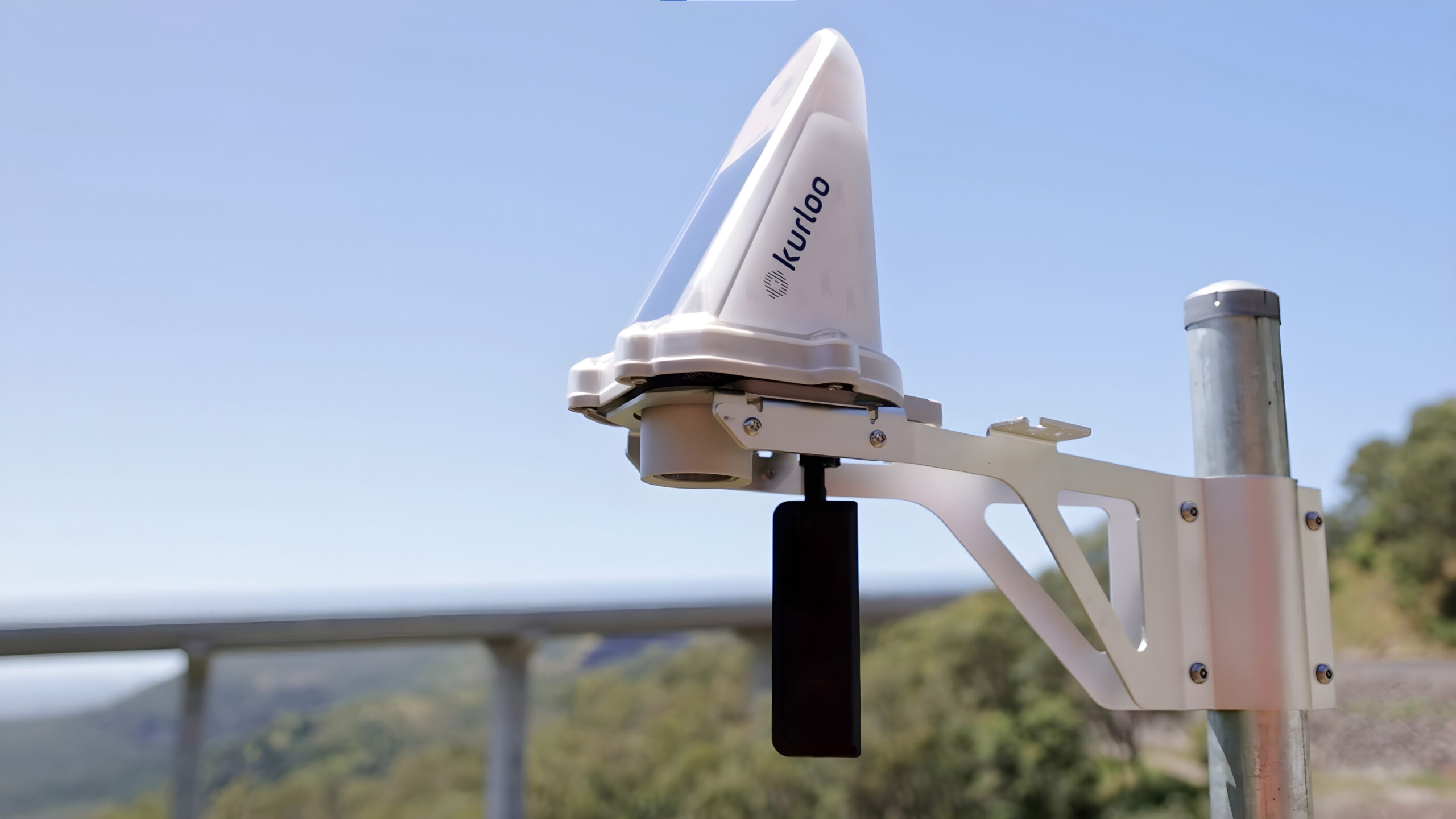
Kurloo’s form directly responds to the functional requirements of the product. The angular front maximises solar input,
encourages water runoff and reduces dust accumulation. The rounded top removes the requirement for bird spikes and forms
a GNSS antenna radome, while the flat underside sets a datum plane for the ultrasonic sensor.
The aesthetic is akin to environmental monitoring stations, reflective of the watchful purposeful technology within.
Function
Kurloo delivers the core function of structure displacement monitoring and designed for ease of use. The installation procedure is quick, simple, requires only basic tools, and the status indicator LEDs are readily visible.
Benefitting from local development.
IntelliDesign saw the potential of the Kurloo product, and worked closely with the Kurloo team to ensure designs were fit for purpose, and met all the customers requirements. With a project like Kurloo, our customers success is our success, so we work to ensure our customers products provide the best possible outcome. As a result of the close partnership, the Kurloo monitoring station was the recipient of several awards, including the Australian Good Design award, and the 2023 Asia Pacific Spatial Excellence Award.
Innovation Focus
Utilising GNSS for precise positioning requires a sensitive and high-quality geodetic grade antenna taking multiple
measurements over several hours. This in turn requires careful power management for a self-powered device. Only through
iterative design and testing was a solution found to be viable for a mass IoT unit production and operation.
Data Science
Managing natural environments and the ever-growing legacy of infrastructure, all impacted by climate change, is a major challenge in which data science must lead the way. Data science has an equally leading role in delivering construction safely and sustainably with less cost and time overruns.
Product Features
Precision 3mm measurement accuracy for three dimensional displacement
Multi- constellation GNSS, IoT and cloud computing technology
Accelerometor for disturbance detection
Designed with a wide operating temperature range -40°C to +85°C.
IP66 rated for harsh environments
Battery powered with solar charging for self sufficient remote operation
Ultasonic ground level sensor
Over-the-air firmware updates
Wide stakeholder engagement leading to customisation of software, hardware, packaging and logistics
Entirely developed and manufactured by our in-house Brisbane engineering team under AS9100D Aerospace quality system.
80% reduction in costs associated with monitoring
Fast Installation in under 2 hours
Deployed in Australia and internationally, monitoring assets and infrastructure in a range of environments